Context-Sensitive Design and Development
Context-sensitive design considers the features of the surrounding area to ensure that new development and redevelopment is complementary and contributes to a cohesive, sustainable, and resilient neighborhood or district. In Lakewood, most new development is infill development or redevelopment, which heightens the importance of promoting and regulating development to be intentional, context sensitive, and community-oriented.
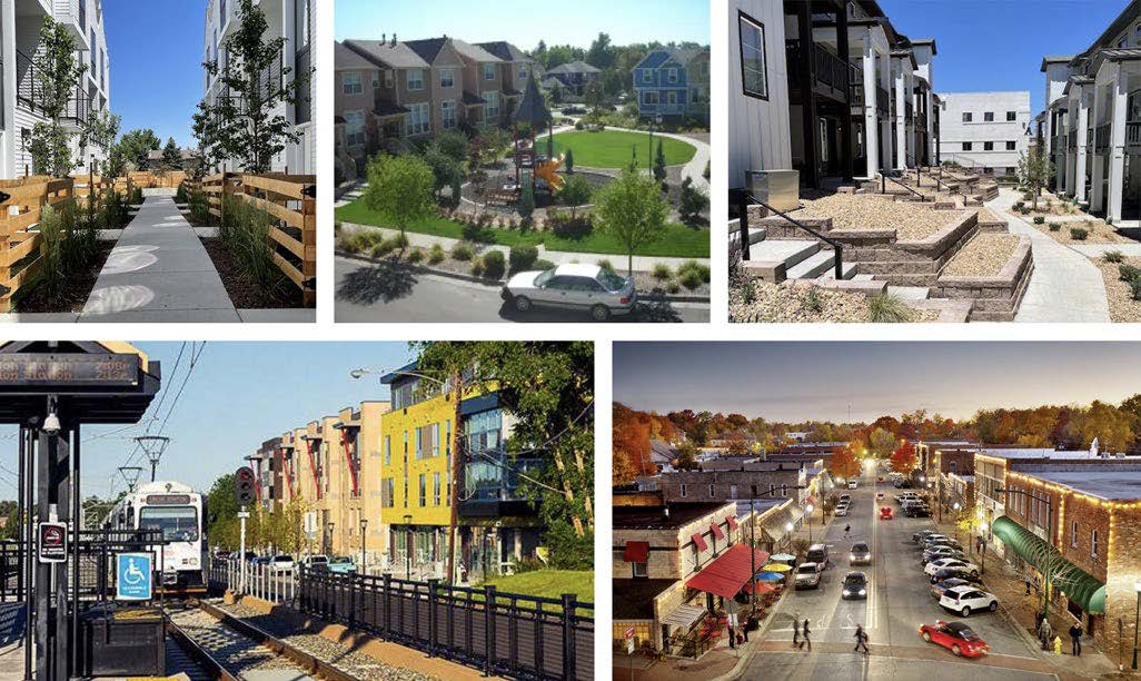
Much of Lakewood’s recent new development has occurred along major corridors like West Colfax Avenue, Union Boulevard and Wadsworth Boulevard and each corridor has distinct development patterns. Lakewood’s area plans provide clarity on the type of design and development appropriate for corridors and other specific areas of the city. These plans are based on community input and outline the vision and recommendations for the future. Relevant plans include the Downtown Lakewood Connectivity and Urban Design Plan, the Union Boulevard Corridor Urban Design Plan, the 40 West Arts District Urban Design and Mobility Concepts, the West Colfax 2040 Vision Plan, the Sheridan Station 20-Minute Neighborhood Implementation Strategy, and the 40 West ArtLine Framework Plan and Design Standards and Guidelines.
The Lakewood Zoning Ordinance is the City’s regulatory tool to guide design and development. The Zoning Ordinance specifies three context zones: 1) Transit Context, which is near light rail stations, 2) Urban Context, which is more pedestrian-oriented, and 3) Suburban Context, which is more auto-oriented. These zones establish dimension standards, development standards, and design standards, such as setbacks, build-to zones, required open space, allowed building heights, land use, and parking. The City is also exploring adding a Creative Context zone for areas that have a focus on creative uses and design in a walkable pedestrian-oriented area, like the 40 West Arts District.
Goal 15 Strategies: Context-Sensitive Design and Development
As more redevelopment and infill projects are proposed and built in Lakewood, it is important to the community that the development is attractive, high- quality, sustainable, and economically resilient. Primary strategies for this goal promote the strategic use of regulatory, planning, and incentive-based tools, such as revisions to the City’s zoning code to align with all development goals in this Plan and the Future Land Use Map. Supporting strategies show the connections between development and civic participation, equity, community health and safety, sustainability, transportation and economic development.
Primary Strategies
-
Implement a collaborative approach to develop context- sensitive area plans for targeted corridors, neighborhoods and activity hubs, prioritizing areas with high redevelopment pressure, displacement concerns, environmental hazards, infrastructure needs or other factors to create equitable planning processes. The outcome of these plans can help identify area assets and opportunities for change that are reflective of community input and cohesion.
-
Use the City’s implementation tools such as the Zoning Ordinance, Design Standards, Major Site Plan Review and other applicable regulations to promote development that is respectful of adjacent properties and the surrounding area by considering height, scale, design, connectivity and impacts to the environment. Update these tools as needed.
-
Support the Design Review Commission in applying Design Standards and Guidelines. Explore opportunities to strengthen the program and consider the development of additional design standards as resources and priorities allow.
-
For all development projects, promote accessible, human-scaled design that enhances the aesthetics of the site and includes quality, well-detailed, and durable materials.
-
Support zoning and regulatory changes that align with the Future Land Use Map.
Supporting Strategies
-
Update regulations for public space design to support the community’s physical, mental, and social health, with considerations such as passive and active uses, places to gather, heat resilience, connections to nature, and safe access within and through a space.
-
Develop and maintain green and gray infrastructure that supports public health and safety, reduces risk of hazards, integrates into pedestrian-friendly streetscapes, and supports a healthy natural environment through implementation of nature- based solutions that promote climate mitigation, adaptation, and resilience. Assess and identify opportunities to mitigate existing hazards and enhance climate resilience of infrastructure, city assets, and communities.
-
Building on existing efforts, develop and implement a comprehensive strategy for proactively addressing environmental justice across all relevant City operations. As a baseline, this strategy should be informed by the regular collection and monitoring of necessary data—both quantitative and qualitative.
-
Invite, encourage, and work to remove barriers for residents to take an active role in the city through intentional offerings for civic participation that actively fosters interaction between residents of different backgrounds and experiences. This may include, but not be limited to, elections, volunteering, applying for city grants, joining city boards and commissions, providing public comments on projects, participating in planning processes, accessing special events, participating in creative placemaking efforts, or other public participation processes.
-
Promote building longevity through use of high-quality durable materials, multifunctional and flexible design, adaptive reuse and retrofitting programs, sustainable design, and deconstructability.
-
Continue to implement the 40 West ArtLine Framework Plan and any future updates to the Plan.
-
Improve and activate publicly owned spaces (such as parks, plazas, streetscapes) with art, landscaping, seating, creative placemaking, and interactive elements.
-
Identify under-utilized and under-performing commercial areas and assist in their revitalization, including decarbonization, through the use of state and federal programs such as enterprise zones, the Lakewood Reinvestment Authority (LRA), and other programs and financial incentives.
-
Implement a comprehensive building program that increases energy efficiency and renewable energy and storage, eliminates emissions, and makes buildings more resilient by incorporating performance standards, code updates, customized tools, resources and incentives, workforce development, financing mechanisms, and community education.
-
Regularly review and adopt updated building and energy codes to protect life and safety, support Lakewood’s housing, climate, and economic development strategies, and to accelerate progress towards greenhouse gas reduction targets through sustainable design, resource efficiency, decarbonization, and climate resiliency of buildings.
-
Regularly assess and update Lakewood’s Zoning Code, engineering standards, and other related land-use policies to ensure that development projects account for climate risks, advance the City’s climate commitments and reflect the community’s adopted vision.
-
Develop and implement a citywide multi-modal transportation plan that includes updates to the existing roadway classifications and establishment of modal hierarchies to create a coordinated and cohesive vision for Lakewood’s future transportation system.
-
Continue to ensure that the safety and access needs for all modes of transportation users are considered with future transportation improvements, including but not limited to pedestrians, cyclists, and equestrians.
-
Prioritize gaps in the network grid, first and last mile connections, improvements to overall connectivity and a greater variety of route options to more efficiently move people through Lakewood.
-
Continue to implement transportation related plans and studies and any future updates.
-
Support greater density in areas well-served by transit and greater transit service and a greater variety of transportation options in denser areas, while ensuring a dense pedestrian-network where residents have safe and convenient access to destinations and the transportation network, while also considering area context.
-
Re-examine the Zoning Ordinance and other regulations and policies to better integrate multimodal street classifications with land use, environmental considerations, and built form context. Align street typologies with land use and zoning, addressing elements such as setbacks, build-to-zones, sidewalks, landscaping, right-of-way (ROW) and roadway improvements, access requirements, auto-oriented land uses, and others.
-
Modify the parking requirements in the Zoning Ordinance to be consistent with the context of the area, applicable state laws, and best practices to calibrate a balance between sufficient parking, vibrant places, and reducing harmful environmental impacts such as heat islands.
-
Develop and support creative and innovative partnerships to explore financing mechanisms and work collaboratively towards shared economic goals for the city.