Enhanced Corridors
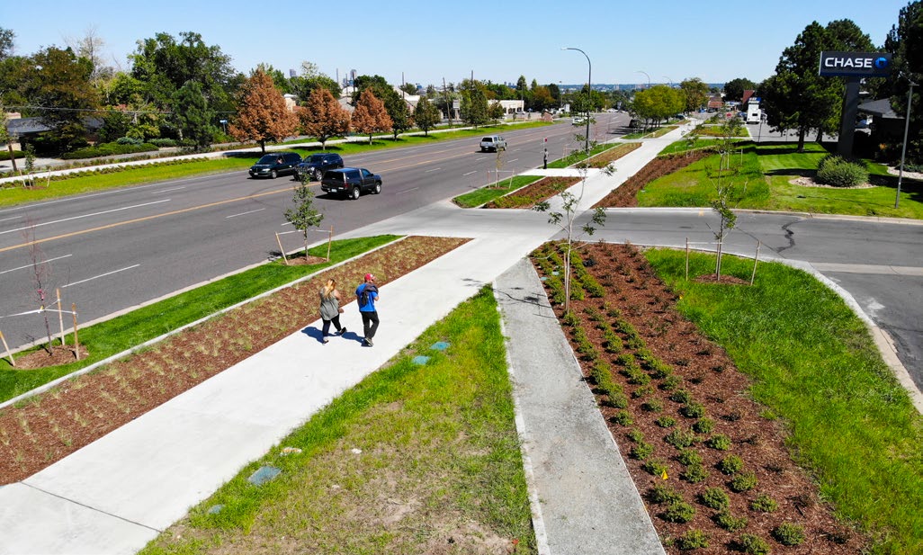
Lakewood’s major roadway corridors provide essential pathways to efficiently move people and goods, and to provide access to different areas and destinations around the city and the broader region. The land adjacent to these corridors supports local retail and service establishments for the community, and sometimes also includes sections lined with residential homes. These corridors were designed and developed in a way that prioritizes travel speeds, high roadway capacity, and primarily auto-oriented development. This has left many of Lakewood’s roadway corridors unattractive and dangerous for non-vehicle users such as pedestrians, cyclists, and transit riders. It has also left most of these corridors in uninspiring conditions that lack the vibrancy and sense of place that invite visitors to gather and linger.
Lakewood’s roadway corridors will continue to serve as vital mobility thoroughfares and areas of commerce, but they are also envisioned to be vibrant, pedestrian-friendly spaces that prioritize safe multimodal access and a greater variety of uses and activities. Anticipated regional growth creates a need to increase the availability of jobs, services, retail, leisure opportunities, and housing in the area. Similar to the Activity Hubs, the community has placed an emphasis on concentrating a significant portion of this development in thoughtfully designed mixed-use spaces along corridors that are broadly accessible and offer attractive living environments and conveniences. This will allow the community to evolve in a proactive and welcoming way, while minimizing potential impacts on established adjacent residential neighborhoods and protected open spaces.
As illustrated in the Envision Lakewood Future Land Use Map, the community has identified portions of nine roadways as “Community Corridors” or “Neighborhood Corridors.” Together, these future Corridor destinations are characterized by a linear arrangement of integrated land uses along major roadways, including retail, services, offices, dining, hospitality, and residences. These corridors will balance the need for efficient movement of people, vehicles and goods with an inviting, comfortable, and safe pedestrian environment. Community Corridors are meant to serve a broader community and regional scale, while Neighborhood Corridors are meant to serve the local residences that surround them.
In addition to developed roadway corridors, Lakewood has many natural and wildlife corridors that provide close-to-home access to greenspace and diverse habitats for local wildlife while also creating connectivity and multimodal transportation opportunities in some cases. As shown on the Envision Lakewood Future Land Use Map, these corridors are often connected to parks and open space, further enhancing their value. Natural and wildlife corridors have a positive impact on community health, sustainability, multimodal transportation, equity, and economic development and are an important part of Lakewood’s identity.
Goal 14 Strategies: Enhanced Corridors
To realize this goal of curating a network of well-designed and enhanced corridors, primary strategies focus on continued area and neighborhood planning to define the specific priorities for each corridor, investment in high-quality streetscapes, green infrastructure, and beautification, and the use of regulatory tools to promote integrated and aligned Corridors and Activity Hubs. Supporting strategies link corridor planning with multimodal transportation, community health and safety, equity, economic development, sustainability, and context sensitive development.
Primary Strategies
-
Implement a collaborative approach to develop context- sensitive area plans for targeted corridors, neighborhoods and activity hubs, prioritizing areas with high redevelopment pressure, displacement concerns, environmental hazards, infrastructure needs or other factors to create equitable planning processes. The outcome of these plans can help identify area assets and opportunities for change that are reflective of community input and cohesion.
-
Support the development of areas with a mix of uses within activity hubs and along corridors to integrate and connect residential, commercial, and recreational spaces, fostering vibrant, walkable communities.
-
Integrate natural spaces, tree-lined streets and green infrastructure into site and corridor planning and recreational spaces to improve air quality, support biodiversity, create connected pedestrian greenways and enhance the safety and aesthetics of the corridor
-
Promote sustainable and integrated development along Lakewood’s corridors that enhances safe and multi-modal connectivity, accessibility, and quality of life.
-
Support future efforts to more specifically define and plan for a hierarchy of corridor types in Lakewood.
Supporting Strategies
-
Update regulations for public space design to support the community’s physical, mental, and social health, with considerations such as passive and active uses, places to gather, heat resilience, connections to nature, and safe access within and through a space.
-
Develop and maintain green and gray infrastructure that supports public health and safety, reduces risk of hazards, integrates into pedestrian-friendly streetscapes, and supports a healthy natural environment through implementation of nature- based solutions that promote climate mitigation, adaptation, and resilience. Assess and identify opportunities to mitigate existing hazards and enhance climate resilience of infrastructure, city assets, and communities.
-
Building on existing efforts, develop and implement a comprehensive strategy for proactively addressing environmental justice across all relevant City operations. As a baseline, this strategy should be informed by the regular collection and monitoring of necessary data—both quantitative and qualitative.
-
Enhance the urban tree canopy by planting trees along trails, sidewalks, parks, and waterways in priority heat risk areas and targeted areas identified through regular canopy assessments; developing an urban forestry plan; and engaging the public through educational materials, discounted tree sales, and tree planting events.
-
Improve and activate publicly owned spaces (such as parks, plazas, streetscapes) with art, landscaping, seating, creative placemaking, and interactive elements.
-
Identify under-utilized and under-performing commercial areas and assist in their revitalization, including decarbonization, through the use of state and federal programs such as enterprise zones, the Lakewood Reinvestment Authority (LRA), and other programs and financial incentives.
-
Use the City’s implementation tools such as the Zoning Ordinance, Design Standards, Major Site Plan Review and other applicable regulations to promote development that is respectful of adjacent properties and the surrounding area by considering height, scale, design, connectivity and impacts to the environment. Update these tools as needed.
-
Develop and implement a citywide multi-modal transportation plan that includes updates to the existing roadway classifications and establishment of modal hierarchies to create a coordinated and cohesive vision for Lakewood’s future transportation system.
-
Continue to ensure that the safety and access needs for all modes of transportation users are considered with future transportation improvements, including but not limited to pedestrians, cyclists, and equestrians.
-
Prioritize gaps in the network grid, first and last mile connections, improvements to overall connectivity and a greater variety of route options to more efficiently move people through Lakewood.
-
Continue to implement transportation related plans and studies and any future updates.
-
Re-examine the Zoning Ordinance and other regulations and policies to better integrate multimodal street classifications with land use, environmental considerations, and built form context. Align street typologies with land use and zoning, addressing elements such as setbacks, build-to-zones, sidewalks, landscaping, right-of-way (ROW) and roadway improvements, access requirements, auto-oriented land uses, and others.
-
Develop a micromobility strategy that addresses the safety, access, comfort, and convenience of vulnerable road users, and parking or storage for these methods, including people walking and rolling by all modes, including wheelchairs, skateboards, scooters, strollers, bikes, one-wheels and more.
-
Continue to implement the Bicycle Plan and any future updates to the Plan, with a core goal of increasing bicycle network connectivity and increasing the comfort of existing bicycle facilities.
-
Improve the pedestrian environment to ensure that residents and community members have safe, comfortable and convenient access to destinations such as schools and the public transit network. Consider the development of a walkability plan that would also include information and education programs to improve transportation safety and wayfinding.
-
Prioritize closing gaps in the network grid and first/last mile connections, including construction of missing sidewalk and trail links throughout the city, such as those identified in the Belmar/downtown Lakewood Connectivity Study, and north-south crossings of the 6th Avenue freeway, in order to improve overall connectivity, and provide more/greater variety of route options. Prioritize investing in additional separated bike lanes as proposed in the Bicycle Plan.
-
Evaluate locations where it is appropriate to install pedestrian, cyclist, and equestrian crossing improvements such as enhanced crosswalks, signals, refuge medians, or increased visibility at high-traffic mid-block locations and work with the Colorado Department of Transportation (CDOT) and other partners to implement improvements.
-
Support the development, growth, and retention of local businesses.